Introduction
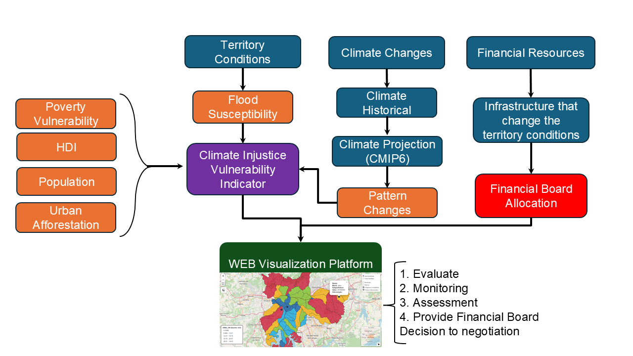
The Dashboard of Climate Justice is an interactive platform designed to support the analysis of the Climate Injustice Vulnerability Indicator and some of its parameters, such as Vulnerability to Poverty and Flood Susceptibility in urban territories.
By integrating spatial data, thematic indicators, and interactive cartographic visualizations, the dashboard enables users to explore the distribution of flood prevention investments across the territory and compare it with the most vulnerable municipalities in terms of climate injustice (identified by this project as high-priority areas).
Climate Justice
According to the United Nations (UN) and the Intergovernmental Panel on Climate Change (IPCC), Climate Justice addresses the systemic inequalities that shape both exposure to climate risks and the capacity to respond to them. It is a principle that recognizes the disproportionate impact of climate change on socioeconomically vulnerable communities.
Climate Injustice is therefore closely tied to adaptation and resilience, as unequal access to resources, infrastructure, information, and decision-making processes limits the ability of the most affected communities to adapt to climate impacts and recover from climate-related hazards. Addressing it requires inclusive adaptation strategies that strengthen local capacities.
Learn more at IPCC – Glossary and UN – Climate Justice Global Alliance.
Objectives of the platform
- To visualize spatial patterns of climate injutice and flood-prevention investments;
- To support decision-making processes related to urban planning, flood prevention and climate adaptation;
- To promote transparency and accessibility of public investments.
How this platform works
The navigation menu at the top of the page allows users to switch between different thematic views, including Flood Susceptibility, Vulnerability to Poverty, and the Climate Injustice Vulnerability Indicator results.
Each map is fully interactive and supports:
- Zooming and panning for spatial exploration;
- Layer activation and deactivation;
- Visual inspection of thematic legends;
- Access to contextual information through popups.
The Climate Injustice Vulnerability Indicator is based on a combination of socioeconomic vulnerability, susceptibility to flooding and increase in extreme rainfall parameters.
Use the interactive map above to identify your municipality and compare levels of climate injustice across municipalities with the spatial distribution of FEHIDRO-funded investments in flood prevention.
Note: Due to the complexity of spatial data processing, some maps may take a few seconds to load depending on the user’s connection and device.